Orange Juice for Scale
Avery clearing off some streambed caliche with a dry tuft of unknown vegetative matter (Deciembre 2018, Hidalgo, Nuevo Leon, México):
 Jugo de naranjo para escamas (orange juice for scale).
At first we wondered how a batch of concrete found its way to this stream bed!
No. This is no ordinary concrete. Avery and I had found our very first caliche sample in the field whilst kicking about an unnamed dry streambed cutting through the vertical Potrero Chico limestones and dolomites.
My friend Kristin just two months back read a paper: the vertical tilts, folds, anticlines of Potrero Chico were inspired by Gulf of Mexico spreading during the late Paleozoic to Mesozoic ~ 300 Ma (1).
I'm sitting in the Gulf now - Keathey Canyon, GPS 29 deg 6' 14.318" N, 92 deg 2' 47.45" W, thinking about tectonics in my neighborhood (this is a different rig. My GPS can't reach the satellites at my current rig!)

You look out into the Gulf and it's serene, relatively monotonous to the untrained eye... but can you imagine the subsea brine pools?
Can you think back to the pod of dolphins the mud engineer pointed out to you one night as you walked past the shaker house, and you watched for ten minutes in silent admiration and awe?
Can you look out at the curious yacht and fisherboats cruising by here and there, out for a catch? Marveling at the massive creations that are offshore drilling platforms...

We're just made of sequences of memories, afterall.
The brine pools... remember that time you navigated a submarine through the lava lamp sitting on your brother's basement night stand (sitting atop a fiery yellow shag carpet, surrounded by wainscotting and dim warm lights, the year is March 4th 1973, and someone has slipped something funny in your drink....).
You're cruising around the lava lamp enjoying the sunset (which is actually just the basement living room light flickering out) and bump into a rising blob. You jatter to a halt! Who put that there! Density contrasts are at it again. Your vessel glides easily through the less dense medium, but bumps into the denser blobs (what are those made of, anyway?)

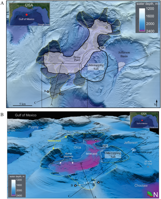
The same happened to a Louisiana team exploring the 650' depths of near-shore Gulf waters (2). Their unmanned submarine had found a brine pool:


A lake has a shoreline, ripples. So do ocean bottom brine pools - pretty trippy.

References
(1) J. F. Longoria. Tectonic transpression in the Sierra Madre Oriental, northeastern Mexico: An alternative model. 1985.
(2) https://oceanexplorer.noaa.gov/explorations/02mexico/background/brinepool/brinepool.html
(3) Submarine Landslides Induce Massive Waves in Subsea Brine Pools Derek E. Sawyer, R. Alan Mason, Ann E. Cook & Alexey Portnov https://www.nature.com/articles/s41598-018-36781-7

At first we wondered how a batch of concrete found its way to this stream bed!
No. This is no ordinary concrete. Avery and I had found our very first caliche sample in the field whilst kicking about an unnamed dry streambed cutting through the vertical Potrero Chico limestones and dolomites.
My friend Kristin just two months back read a paper: the vertical tilts, folds, anticlines of Potrero Chico were inspired by Gulf of Mexico spreading during the late Paleozoic to Mesozoic ~ 300 Ma (1).
I'm sitting in the Gulf now - Keathey Canyon, GPS 29 deg 6' 14.318" N, 92 deg 2' 47.45" W, thinking about tectonics in my neighborhood (this is a different rig. My GPS can't reach the satellites at my current rig!)

You look out into the Gulf and it's serene, relatively monotonous to the untrained eye... but can you imagine the subsea brine pools?
Can you think back to the pod of dolphins the mud engineer pointed out to you one night as you walked past the shaker house, and you watched for ten minutes in silent admiration and awe?
Can you look out at the curious yacht and fisherboats cruising by here and there, out for a catch? Marveling at the massive creations that are offshore drilling platforms...

We're just made of sequences of memories, afterall.
The brine pools... remember that time you navigated a submarine through the lava lamp sitting on your brother's basement night stand (sitting atop a fiery yellow shag carpet, surrounded by wainscotting and dim warm lights, the year is March 4th 1973, and someone has slipped something funny in your drink....).
You're cruising around the lava lamp enjoying the sunset (which is actually just the basement living room light flickering out) and bump into a rising blob. You jatter to a halt! Who put that there! Density contrasts are at it again. Your vessel glides easily through the less dense medium, but bumps into the denser blobs (what are those made of, anyway?)

The same happened to a Louisiana team exploring the 650' depths of near-shore Gulf waters (2). Their unmanned submarine had found a brine pool:
See the creatures in the back? https://www.amusingplanet.com/2018/11/brine-pools-lakes-under-ocean.html
This crab fell into the salty "pit of despair," and will surely be well-preserved for a curious paleontologist to discover in a few ten-million years! If a subsea landslide doesn't take it out...
A lake has a shoreline, ripples. So do ocean bottom brine pools - pretty trippy.
See that yellow white 'ancient salt deposit'? Here we go...
...tectonics come into play like this: go find a pail of water. Get yourself a 3:10 ratio of salt:water going (I made that ratio up. Basically, a lot of salt!). Move to the Utah desert and set the pail on your sunbaked July porch. Come back three days later. What do you see? What has the sun done to your pail?
Water evaporated, salt remains!
Now pour X amount of sand, silt, clay, anything sediment-like you can find on the salt. Sit on it - invite your friends over to pile onto the salt-sediment cake with you.
After a few hundred thousand years and 1,000s of friends, your salt will grow uneasy!
Under pressure... pushing down on me, the salt will NOT compress like your run of the mill sandstone. It will move about 'plastically.'
Where to?
Anywhere it can... anywhere in the path of least resistance, down Alley 64 toward Main Street (or through sediment fractures).
It domes up as a salt diapir, and that's why I'm writing you from the Gulf of Mexico - because those salt domes often hang around oil and gas deposits and then a group of humans decides it fancy to suck that from the ocean bottom. We call it the Louann (salt) out here, and we sure do see this salt under a microscope when IDing drilled well samples:
Thankfully salt diapirs don't always mean oil deposits: about six exploratory wells drilled around Moab, UT in the 90s came back dry (thank heavens), and we don't have any derricks derricking about the fantastic Moab landscape (though I suppose any landscape is wonderful and would be spoiled by a derrick... though, some areas ought to be set aside for enjoyment. We wouldn't build a derrick in Central Park, now would we?)
insert salt photo
These places could be an oilfield someday... tens millions years from now.
Atacama Desert, Black Rock Playa,...
 (3)
(3)
"The age of the brine pool is 7900–8500 years before present as determined by 14C and microfossil dating of the sharp interface that separates black anoxic clays from gray oxic clays." (3)
This Onion Creek Diapir can be admired at the surface:
insert phot
But where were we? Potrero Chico....

These vertically tilted layers are all thanks to the Gulf of Mexico spreading 300 mya!
I'll elaborate more later on...
~ ~ ~
It domes up as a salt diapir, and that's why I'm writing you from the Gulf of Mexico - because those salt domes often hang around oil and gas deposits and then a group of humans decides it fancy to suck that from the ocean bottom. We call it the Louann (salt) out here, and we sure do see this salt under a microscope when IDing drilled well samples:
Thankfully salt diapirs don't always mean oil deposits: about six exploratory wells drilled around Moab, UT in the 90s came back dry (thank heavens), and we don't have any derricks derricking about the fantastic Moab landscape (though I suppose any landscape is wonderful and would be spoiled by a derrick... though, some areas ought to be set aside for enjoyment. We wouldn't build a derrick in Central Park, now would we?)
insert salt photo
These places could be an oilfield someday... tens millions years from now.
Atacama Desert, Black Rock Playa,...
 (3)
(3)"The age of the brine pool is 7900–8500 years before present as determined by 14C and microfossil dating of the sharp interface that separates black anoxic clays from gray oxic clays." (3)
This Onion Creek Diapir can be admired at the surface:
insert phot
But where were we? Potrero Chico....

These vertically tilted layers are all thanks to the Gulf of Mexico spreading 300 mya!
I'll elaborate more later on...
~ ~ ~
I think the world's really beautiful, with its different densities and matter phases and invisible forces... gravity and magnetospheres, ionospheres and magnetism, salt diapirs and oceanic currents. Sometimes I want to enjoy it without the attached scientific terms... afterall, a chemophile doesn't marvel at its methane diet... it just does its thing.
I think we can have a nice time removing ourselves for a moment from our analytical curious minds. A trout swimming in the lakes of the La Sal mountains, a flamingo basking in the Atacama desert doesn't need to read a single published article to know that everything in the world is connected.
References
(1) J. F. Longoria. Tectonic transpression in the Sierra Madre Oriental, northeastern Mexico: An alternative model. 1985.
(2) https://oceanexplorer.noaa.gov/explorations/02mexico/background/brinepool/brinepool.html
(3) Submarine Landslides Induce Massive Waves in Subsea Brine Pools Derek E. Sawyer, R. Alan Mason, Ann E. Cook & Alexey Portnov https://www.nature.com/articles/s41598-018-36781-7


Comments
Post a Comment